Original article: Monitoring cultural heritage by comparing DEMs derived from historical aerial photographs and airborne laser scanning
Invaluable cultural sites that are sometimes thousands of years old are constantly at risk, mainly because of time and well… us. We take things apart, break them, stand on them, and alter the environment, by the simple act of existing. This is why monitoring is a crucial component of cultural heritage research—it allows us to detect changes in sites, structures, or objects that occur over time. These changes may be used to design preservation strategies, and when these changes are quantified, they can help assess the effectiveness of already-implemented tactics.
One of the most important questions to ask when monitoring a site or a structure is: what data do we need in order to understand what’s happening to it? That’s exactly the question Risbøl et al. have addressed in their assessment of the largest rolling stone beach in Norway, Mølen, which is a part of the terminal moraine Vestfoldraet, a relic of the most recent ice age. At Mølen, you can find over one hundred types of rock and numerous rare bird species, but perhaps most notable for cultural heritage researchers are the approximately 230 grave cairns, or ancient burial mounds made of rough stones, that date back to the Roman Iron Age period (1-1000 AD). Some of the cairns may have been constructed as memorials for fallen soldiers or shipwrecked sailors, but burnt stones, which are possible relics of cremation, have also been found.
Since the cairns are not fixed structures, the site is unfortunately susceptible to interference by visitors, who remove stones from cairns, carry them away, and build new mounds of rocks. For this reason, these researchers have decided to generate georeferenced Digital Elevation Models (DEMs) of Mølen at different times throughout the past several decades to see what changes have occurred in the landscape over time.
There are several ways to build three-dimensional (3D) models of a site, and these researchers have chosen two: Aerial Laser Scanning (ALS) and photogrammetry, the use of photographs to make measurements. ALS, which uses an aircraft-mounted laser to build 3D point cloud models of the landscape, is advantageous due to its short data collection time, low cost, high detail, high accuracy, and ability to ‘see’ through vegetation. In fact, it’s the most accurate and detailed method available for this purpose today, but since it’s a fairly new technology, aerial laser scans of sites do not date back very far. Therefore, these researchers have relied on another source of data from the past to generate 3D models of Mølen: historical aerial photographs.
A sufficient number of photographs of an object or site taken from an appropriate number of orientations can be used to generate a 3D model of that object or site. There is software available for carrying out this automatic 3D reconstruction (check out VisualSFM if you’re interested; it’s free for personal, non-profit or academic use, but just don’t forget to cite it). The researchers have used these historical photographs to generate decimeter-resolution DEMs of the Mølen landscape at different points in the past, then georeferenced them to make them comparable to the more recent ALS datasets.
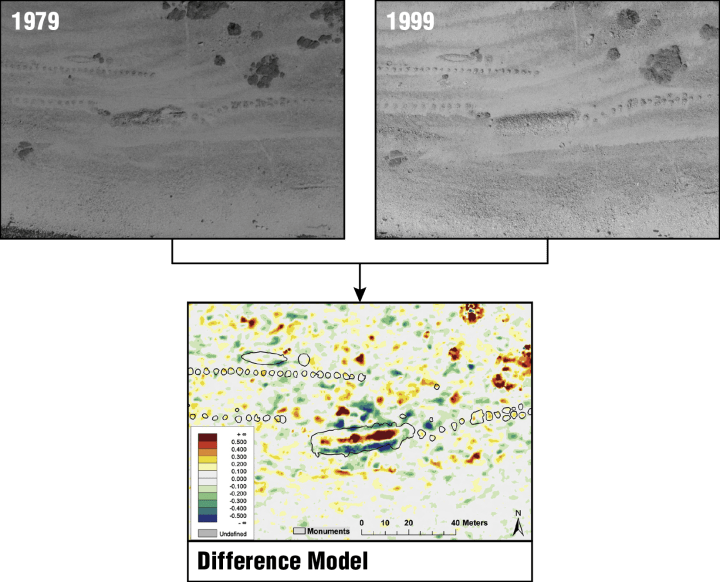
Using these methods, they’ve been able to generate difference models, like the one shown in Figure 1, which shows where parts of the landscape have been raised or lowered between 1979 and 1999. As can be seen in the photographs, this cairn had pits dug into it at one point before the 1979 photograph was taken, and in 1999, rocks were moved from the south of the cairn to its center, seemingly to fill these pits. When cross-referenced with archival studies, it was found that the pits were dug as nests for machine guns during World War II, and these pits were filled to “re-mound” the cairn during a restoration campaign. Data from this work also show where new mounds of stones were placed by visitors, where vegetation grew and was cleared, and where stones were moved from cairns and replaced to explore whether prehistoric graves lay beneath them.
Deciding what data are important, collecting that data (using creative methods, if need be), and critically interpreting the data in the context of history are all essential components in the monitoring of cultural heritage. This study of Mølen illustrates how we can use data from old archives to understand what has happened to a site, monument, or object before the present day. By coupling the information gained from historic aerial photographs with modern ALS data, the researchers were able to develop DEMs that allowed them to ‘navigate’ through space and time. The measured changes in Mølen over time not only informed our historical understanding of the site, but also show potential in being used to inform the design of future conservation strategies. This creative strategy for developing 3D models of historic sites could be extended to all kinds of at-risk sites, whether it be from tourism, natural disasters, international conflicts, or the slow effects of time.
If you’re interested in the details of how Risbøl et al. conducted this work, definitely check out the article linked above!

Very interesting piece. Thanks for explaining advanced techniques in an understandable way!
LikeLike